Sensing
Advertisement
InterIMAGE v.1 27
InterIMAGE is an open source knowledge based framework for automatic image interpretation. You can embed your knowledge into the system to automatically interpret remote sensing images. You can model your knowledge by creating a semantic network.
Advertisement
TempSense Desinger v.1.20.0117
The TempSense Designer software allows the user to easily design temperature sensing circuits for many of the Texas Instruments battery charger devices. A full listing of the supported devices is included under the 'Support' menu in the program.
DGS3100-48 Module v.3.0.0.6
The D-Link® DGS-3100-48 switch provides entry-level, layer 2 managed performance at gigabit speeds. The switch provides 10/100/1000Base-T auto-sensing ports.
Monteverdi-1.8 v.1 8
Monteverdi is an application for capacity building to provide simple remote sensing data analysis tools for non-experienced users. Features: -Different tools can be accessed using the menu.
UIP8000 v.4.0
The UIP8000 software by Telaire corrects error in span calibration process and provides enhanced user interface.Telaire product line boasts over 30 patents related to the design and application of low-cost infrared gas sensing.
CoreMeter v.1.5.0
CoreMeter is a sidebar gadget, monitor your CPU and RAM's usage.CoreMeter Features: 1. Add theoretically as many cores 2. Versatile design settings 3. Various sizes Gadget 4. Diagrams of the monitored values 5. Temperature sensing (Core Temp SpeedFan
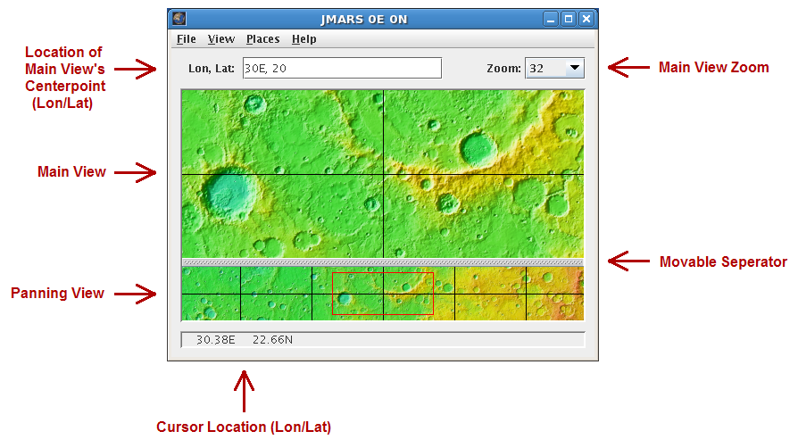
JMARS v.1.25
JMARS is an acronym that stands for Java Mission-planning and Analysis for Remote Sensing.
Echoproc v.0.1.4
Echoproc is a piece of scientific analysis software used to extract physical ice sheet characteristics from radio echograms from experiments like the Center for the Remote sensing of ice sheets (https://www.
HidroSIG v.3.1.1.beta2
HidroSIG is a GIS that supports raster and vectorial maps with modules oriented to the hydrological analysis, time series, remote sensing and more.
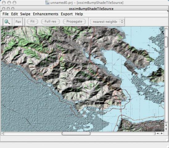
OSSIM - Open Source Software Image Map v.99
Open Source Remote Sensing OSSIM project, pronounced "awesome", will leverage existing algorithms/tools/packages from the open source community in construction of the ultimate Remote Sensing/Image Processing/GIS package.
PT100 Thermoluminescence Rig Routines v.0.9b1
MATLAB driver routines for the thermoluminescence apparatus using PT100 resistors as the heating and sensing elements described in the Review of Scientific Instruments v78, 083905 (2007).